Wow, was it cold as I left my hotel in Cadiz, OH. I was headed to Stuebenville to take a bridge across the Ohio River into West Virginia. Luckily, there was no wind because the air was biting cold. Google Maps plotted a route and the 1st turn wasn't even a street. It could have been a service road but, certainly, not a cycling road. I ended up on Hwy 22 which had a really good and wide shoulder. I didn't see any signs forbidding cycling and felt safe enough.
Day 46 Ride Video
Crossing into a new state is always invigorating and today I crossed into 2 new states. The route in West Virginia was only a few miles to get on the Panhandle Trail. This trail started out unpaved but became paved after 5 miles when it crossed into Pennsylvania. It felt great to be back on a rail trail and not have to deal with cars and traffic.
Panhandle Trail map
Getting on the Panhandle Trail
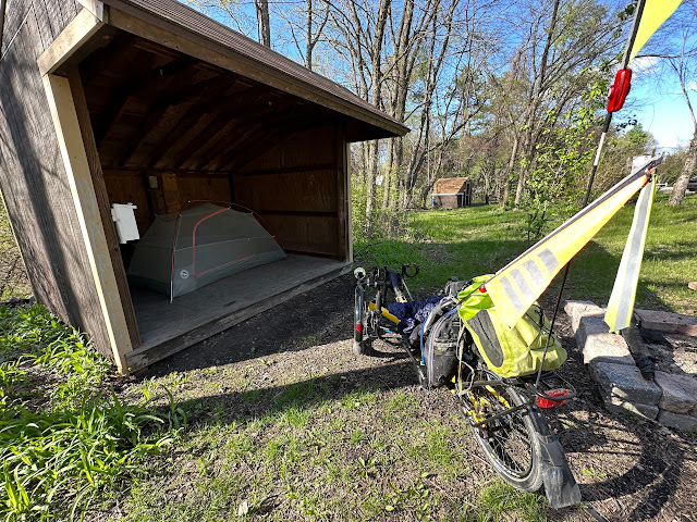
The day was clear but continued to be very cold as I got on the Montour trail. A few people were walking with dogs but fewer cyclists were out riding. I think it was too cold. This trail is interesting in one unusual way. There is primitive camping in the tradition of the Appalachian Trail. I think of this type of camping as hiker/biker where you have to hike or bike in to use the sites. You also have to bring whatever you need as there are no services available. I stopped at the Boggs Monitor campground which had a covered shelter. There was no water or electricity but a porta potty a hundred feet away on the trail. This campground had hammock posts, 3 tent pads, a picnic table, a fire ring, and a place to lock your bike. It was also close to a landfill and there was a constant stream of garbage trucks passing on the road below which was very loud. I set up my tent in the shelter to give me a buffer from the noise.
I love these signs
State Line marker
Tent setup in the shelter
I was lucky to camp here on a Friday night. I expected to hear garbage trucks passing by at 5 am but, apparently, they take Saturday off. Again, in the morning, it was very cold but the forecast was for a warmer day. Today became quite complicated. For some reason, I couldn't get Google Maps to recognize the Montour trail. I needed to make a turn on the trail and missed it. And then I missed it again. I needed to be on a bridge and Google Maps kept putting me on the road below. I asked a passing cyclist where I went wrong and Annie escorted me to the hidden intersection.
Trail map
Good mileage signage
Not a rail trail
The next debacle came when a tunnel on the Montour trail was closed. There is a bike rental shop where the detour is. I explained that I'm trying to get on the GAP trail and they said I had more than 50 miles to ride there. It is unusual for me to calculate the day's mileage so wrong. I had already ridden 28 miles and this would make the ride too long. Once I got on the GAP trail, I had another 15 miles where I had made a reservation at a B&B. I had already changed my reservation twice because of the weather. They were very understanding when I changed the reservation once again.
Montour Trail Primitive Camping
Camping near Pittsburgh
Day 47 Ride video
The detour around the tunnel closure was only a few miles but it was treacherous. The road was in terrible condition with steep climbs and lots of chaotic traffic. I was very relieved to get back on the trail. Since I couldn't make the reservation at the B&B, I needed to find another place to stay. Almost into Pittsburgh, I found another primitive campsite that was right on the trail next to a little creek hidden from the road. The day had warmed up enough to be perfect for camping as well. Today, certainly, turned out much different than I expected.


No comments:
Post a Comment